
Introduction & Data Sources
 The Arizona landscape is no stranger to landslides. The entire spectrum of landslide types – debris avalanche, debris flow, earthflow, creep, rock fall, rock slide, topple, rotational and translational landslides - are encountered here. Landslide features range in size from small localized slides a few tens of feet across to complexes of large slide blocks miles wide.
Source: Arizona Geological Survey - see Further Readings below for details.
Last Updated: Jan. 2018
Related Information
Mitigation Tips
There are actions that you as a homeowner can take to minimize landslide hazards and risk to your family and property.
- Avoid building beneath steep slopes of rock or unconsolidated sediments
- Avoid excavating or or at the base of steep slopes
- Don't add water to steep slopes
- Do drain water away from slopes
- Do plant native ground cover on slopes
- Do consult with a professional before modifying nearby slopes
- Do examine the Natural Hazard in Arizona Viewer for evidence of local landslides
Some indicators of unstable ground:
- Structural deformation such as large foundation cracks, misaligned doorsand windows, tilted floors, or sagging decks
- Large, open cracks in driveways,
- curbs, and roads
- Failing retaining walls
- Arc-shaped cracks in the ground
- New cracks or bulges in the ground
- Leaning telephone poles, trees,
- retaining walls, or fences
Further Reading
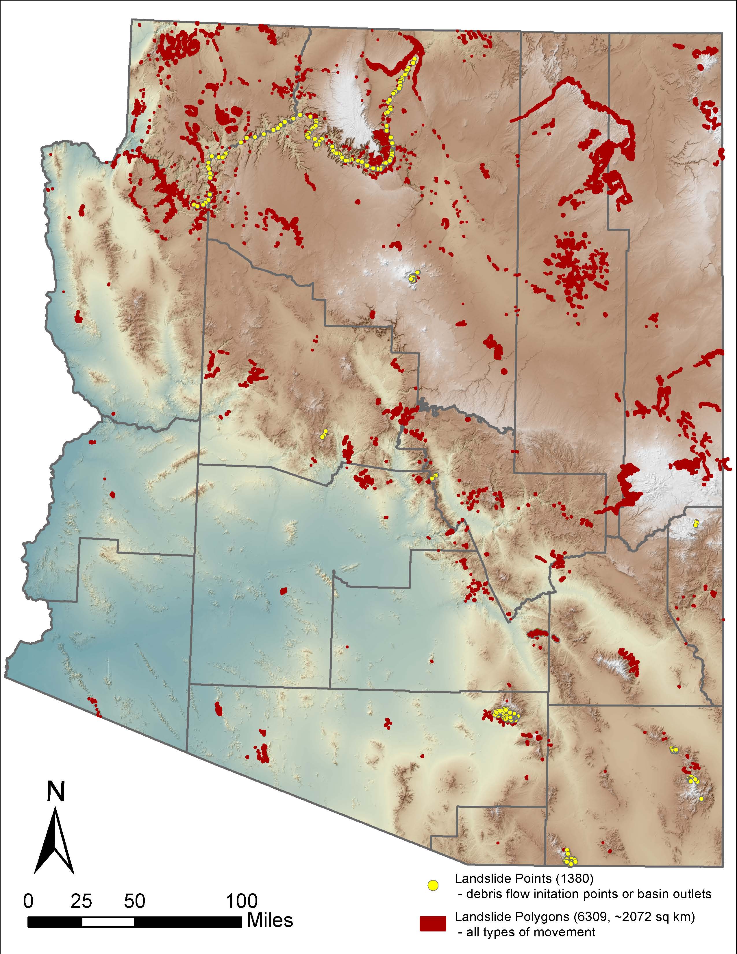 In 2015, AZGS geologists began compiling statewide landslide data to update the Arizona Hazard Mitigation Plan Risk Assessment. Landslides pose a hazard to people, property, and infrastructure such as roads and utilities. The cost to repair highways in AZ due to damage by landslides in recent years exceeds $25 million.
Landslide feature data -e.g., deposits and scarps - were compiled from AZGS and USGS geologic maps, aerial photographs, and Google Earth imagery interpretation. At present, the landslide database includes 4,400 landslide polygons covering over 520 square miles and 1,300 debris flow data points. Many of these landslides are ancient landscape features (Pliocene-Pleistocene) but many are more recent (Holocene to historical). Portions of ancient landslides may reactivate in response to surface modification (e.g., road building that undercuts the toe of unstable slopes) and/or heavy rains.
The building of a statewide landslide database for AZ is an ongoing project and fresh landslide data will be added as it becomes available. AZGS is partnering with local, county, tribal, state, and federal agencies to build a comprehensive, statewide database.